• About me
  • The 1978 Bronx Survey
  • Domino Sugar Factory, before and after
  • St. Augustine Church in the Bronx, before and after

Menu

  • About me
  • The 1978 Bronx Survey
  • Domino Sugar Factory, before and after
  • St. Augustine Church in the Bronx, before and after

Blog Filters

  • All Posts
  • About me
  • Before and after
  • Bronx Survey
  • Gallery
  • Maps
  • Standard
  • Walks

Filters

  • All Work
  • Borough
  • Bridge
  • Bronx
  • Brooklyn
  • Landmark
  • Manhattan
  • Park
  • Queens
  • Subway
  • Theme
  • WTC

Recent Posts

  • James L .and Lucinda Bedell House, before and after
  • Flatbush District No. 1 School, later Public School 90, before and after
  • Long Island City from 34th Street, before and after
  • Hudson Yards, before and after
  • Pepsi-Cola Sign, before and after

Recent Comments

    Archives

    • September 2018
    • August 2018
    • May 2016
    • April 2016
    • March 2016
    • December 2015
    • February 2011
    • January 2011
    • December 2010

    Categories

    • About me
    • Before and after
    • Bronx Survey
    • Gallery
    • Maps
    • Walks

    Meta

    • Log in
    • Entries feed
    • Comments feed
    • WordPress.org

    Geocommons

    January 24, 2011 / Category: Walks / Posted by: Emilio Guerra

    I’m not too sold on Geocommons, a mapping application which is free to use. I am still going to use Google Earth for most things, but I do like how it mashes up data and how it combines KMLs with Shapefiles.

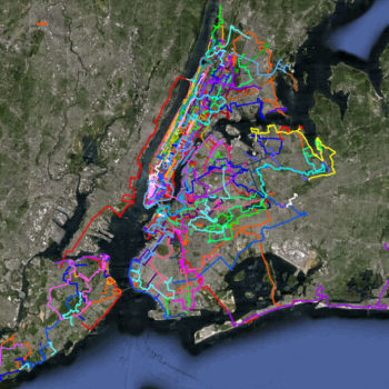
    Below is a map of my walks along with a map of the NYCLPC designated landmarks (and some pending ones, too). If you poke around it’s obvious how I tailor most of my walks around landmarks.

    View full map

    Tags: walking, Walks

    Share Post :

    More Posts

    • Foot of Rochelle Street (1 Rochelle Street)
    • Circle Missions, Inc., former Peabody Residence
    • Gatehouse for the New Croton Aqueduct
    • Chase Manhattan Bank, former North Side Board of Trade
    • 95 Pell Place
    • 2251-59 Loring Place
    • Lloyd Hall
    • St. Raymond's Roman Catholic Church
    • 2744 Kingsbridge Terrace
    • Domino Sugar Factory, before and after
    • Le Gras Hall
    • Grand Avenue between West 190th Street and Kingsbridge Road
    • Butler Hall
    • 350-366 and 361-371 East 198th Street
    • Rice Stadium
    • Rectory of the Church of Saints Peter and Paul
    • Bedford Park Presbyterian Church
    • Former Hupfel Brewery
    • Rectory of Christ Church
    • St. Matthew's African Methodist Episcopal Church
    • First Presbyterian Church of Williamsbridge
    • Villa Charlotte Bronte
    • P.S. 31
    • Mott Avenue Interborough Rapid Transit Station Entrance
    • The Lewis Morris
    • Reformed Church of Melrose
    • St. John's Evangelical Lutheran Church
    • 284 City Island Avenue
    • Henry W. Boettger Silk Finishing Factory
    • Our Lady of Angels R.C. Church Rectory

    Cufo Theme. By Royal-Flush 2014 ©